


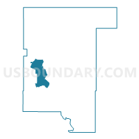
Voting District 29, Rogers County, Oklahoma
About
Outline

Summary
| Unique Area Identifier | 655118 |
| Name | Voting District 29 |
| County | Rogers County |
| State | Oklahoma |
| Area (square miles) | 21.67 |
| Land Area (square miles) | 21.60 |
| Water Area (square miles) | 0.06 |
| % of Land Area | 99.70 |
| % of Water Area | 0.30 |
| Latitude of the Internal Point | 36.32283410 |
| Longtitude of the Internal Point | -95.72560510 |
Maps

Graphs
Select a template below for downloading or customizing gragh for Voting District 29, Rogers County, Oklahoma


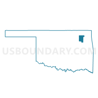
Neighbors
Neighoring Voting District (by Name) Neighboring Voting District on the Map
- Voting District 116, Rogers County, OK
- Voting District 120, Rogers County, OK
- Voting District 14, Rogers County, OK
- Voting District 16, Rogers County, OK
- Voting District 30, Rogers County, OK
- Voting District 32, Rogers County, OK
- Voting District 7, Rogers County, OK
- Voting District 9, Rogers County, OK
Top 10 Neighboring County Subdivision (by Population) Neighboring County Subdivision on the Map
- Claremore CCD, Rogers County, OK (44,138)
- Catoosa CCD, Rogers County, OK (24,115)
- Oologah-Talala CCD, Rogers County, OK (7,180)
Top 10 Neighboring Place (by Population) Neighboring Place on the Map
Top 10 Neighboring Elementary School District (by Population) Neighboring Elementary School District on the Map
Top 10 Neighboring Unified School District (by Population) Neighboring Unified School District on the Map
- Owasso Public Schools, OK (45,456)
- Claremore Public Schools, OK (22,545)
- Collinsville Public Schools, OK (12,082)
- Catoosa Public Schools, OK (11,288)
- Oologah-Talala Public Schools, OK (9,115)
Top 10 Neighboring State Legislative District Lower Chamber (by Population) Neighboring State Legislative District Lower Chamber on the Map
Top 10 Neighboring State Legislative District Upper Chamber (by Population) Neighboring State Legislative District Upper Chamber on the Map
Top 10 Neighboring 111th Congressional District (by Population) Neighboring 111th Congressional District on the Map
Top 10 Neighboring Census Tract (by Population) Neighboring Census Tract on the Map
- Census Tract 504.03, Rogers County, OK (5,193)
- Census Tract 508.01, Rogers County, OK (4,048)
- Census Tract 504.05, Rogers County, OK (3,676)
- Census Tract 503.04, Rogers County, OK (3,235)
- Census Tract 506.01, Rogers County, OK (3,120)
Top 10 Neighboring 5-Digit ZIP Code Tabulation Area (by Population) Neighboring 5-Digit ZIP Code Tabulation Area on the Map
- 74055, OK (38,680)
- 74017, OK (28,057)
- 74019, OK (17,648)
- 74021, OK (17,359)
- 74015, OK (8,064)
- 74053, OK (4,315)